


Navigation
Leica GS20 Field Guide-1.1.0en
43
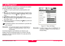
4. Navigation
The navigation application is purely a means to guide the user
to a point with known coordinate values. The points to be
navigated are known in the GPS world as “Waypoints,” from
their origin as destinations along the way. The user also has
the option to navigate to points that have never been visited
before.
Rather than having a special feature code for “Waypoints,” the
Leica Geosystems GS20 uses a database flag in the feature
that can be toggled to define a Waypoint as:
Flagged: As a feature that should be navigated to
or
Visited: Providing closure to the workflow
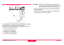
Waypoints can be created in the Leica Geosystems GS20 by
several methods:
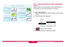
• Selecting points graphically from the mapview in both
Navigation and Data Management.
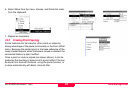
• Tabling a known feature and setting the database
Waypoint flag in Data Management.
• Setting the node on a linear feature as a temporary
Waypoint in both Navigation and Data Management.
• Creating a new Waypoint by entering known coordinates in
Data Management.
• Uploading GIS or CAD data set with a Waypoint flag from
Leica Geosystems GIS DataPro to the Leica GS20.