


Data Collection
Leica GS20 Field Guide-1.1.0en
22
2.2 Background Files in the GS20
Often it is important for a user to see the location of they’re
current position and those Features they have collected within
a larger context. However, it is not always necessary or even
beneficial to have that data selectable. With the ability to
create vector background data, the GS20 can now:
• Attach larger vector reference files
• Use the same vector reference file for multiple jobs
• Reference multiple files to a job
• Reference previously collected jobs in an open job
• Only re-import collected or updated data
2.2.1 Overview
GS20 background files are graphic files that can be created in
GIS DataPRO, and are automatically created when job data
is collected in the GS20. The graphic file contains the file
extension qtr, which stands for quadtree; a method of spatially
indexing vector data. When a job is created in the GS20, a
graphic file of that same name is also created. From job
management, a background screen can be accessed,
allowing the user to reference other “background” graphical
data to the job. Background graphic files are for visual
reference only, and are not selectable.
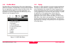
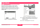
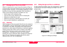
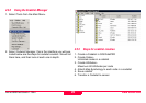
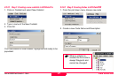
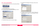
2.2.2 Adding Background Files to a GS20 Job
To add a background Map, enter Job management, highlight
a selected job, and select “Background Maps” from the
context menu.
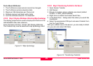
Figure 2-3: Background Maps