


C3608M (9/07) 5
About This Guide
Thank you for purchasing Pelco’s Endura
™
Mapping application. This guide provides instructions on creating maps, editing application settings,
and monitoring alarm events. For proper network configuration, follow the instructions in the Endura Network Design Guide, which is available at
the Pelco Web site (www.pelco.com). For instructions on installing the application, refer to the Endura Mapping Quick Installation Guide.
You also can find complete instructions for operating the application in the online help.
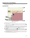
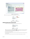
About Endura Mapping
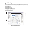
Endura Mapping provides the following features and capabilities:
• Designs, manages, and displays maps of your site.
• Organizes maps into logical groups and links maps together for quick navigation and viewing.
• Imports images created in other drawing applications to serve as backgrounds.
• Imports AutoCAD
®
files that are saved as DXF files.
• Displays camera status and alarm events from icons that are strategically placed on the maps.
• Views video, responds to alarms, and activates relays through icon interaction.
• Integrates camera views with the WS5000 advanced system software.
• Communicates with the Endura system.
For best results when running Endura Mapping, this application should be installed on a computer or Endura Workstation to which two monitors
are attached. Since Endura Mapping can be started directly from the WS5000, operators can view both applications simultaneously on the
separate monitors. In such a working environment, Endura Mapping should be displayed on the secondary monitor.
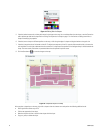
Endura Mapping gives operators the ability to display the physical location of cameras, alarms, and other Endura devices throughout a facility.
Careful integration with the Endura WS5000 Advanced System Software makes setting up a map fast and intuitive. A flexible user interface with
powerful filtering and navigation tools makes working with maps an effective way of monitoring a large and geographically dispersed system for
the operator.
The ability to use maps saved as AutoCAD
®
DXF files or in common graphics file formats allows administrators to quickly import an existing map
to begin building a graphical representation of the site. Direct access to the Endura system means that administrators can assign cameras,
alarms, relays, and other devices to map icons quickly and easily. Icons can be customized in size and color to manage clutter on a map while still
providing an effective way of determining where key components are located. Hyperlinks can be inserted on a map to provide easy linking to
other maps. Maps can be organized hierarchically into meaningful groups. Custom views of each map provide quick navigation through various
map layers to drill down on alarm events at large sites. Custom shape layers, icon layers, and views serve the needs of various operators.
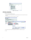
Operators can run Endura Mapping directly from the Endura WS5000 advanced system software. User rights and permissions are managed by
the Endura SM5000 system manager, providing a single database for managing operator access to all Endura applications. Animated icons on
maps indicate alarm severity as configured in Endura. The Map Browser automatically tallies the alarms as they occur in the system so that
operators can quickly see the number, severity, and location of alarms from a single list. Operators can click an icon to access and acknowledge
alarms, activate relays, view live video, and manage monitor wall displays without exiting Endura Mapping.