


C3608M (9/07) 11
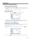
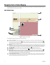
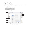
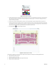
• Scale: The scale of a map determines the ratio of the actual physical space that the map represents in relation to the map as it is viewed
in Endura Mapping. Map scale is adjusted based on the unit of measurement (standard or metric) that is set for the map each time you
zoom in or out of the map. When setting the scale of a map, the following optional settings are available:
– System of measurement: Maps can be measured using either the standard system (miles, feet, inches, etc.), or the metric system
(kilometers, meters, centimeters, etc.).
– Width and height: These settings determine the virtual dimensions of the map as viewed in Endura Mapping. Width and height can
be greater than the available screen size. When the width and height are greater than the screen size, vertical or horizontal scroll bars
are provided in the Map Viewer. When the entire map is visible in the Map Viewer, the scroll bars are not available.
– Conversion chart: A conversion chart provides the relationship of a unit of measurement on the map to the physical space the map
represents. For example, a mile might be represented on the map by a single inch or centimeter. If necessary, degrees on the globe can
be converted to smaller units of measure. When converting to degrees, only the width of the map can be scaled to degrees. Expressed
as Latitude (Lat.°) on the conversion chart, one degree represents 69.2 miles (111.37 km).
– Physical location (latitude and longitude): The physical location of a map identifies the actual position of the upper-left corner of
the map on the Earth. This location is determined by entering the latitude and longitude of the upper-left corner of the map.