


10 C3608M (9/07)
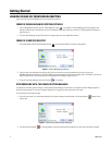
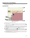
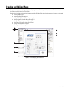
Elements of a Map
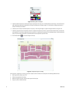
A map is a graphical representation of a physical space, such as a building or floor plan, or a geographical location, such as a city or
neighborhood. A site might require one or more unrelated maps to represent its security system, or several maps might be needed that can be
related hierarchically. In such a hierarchical relationship, one map is considered the parent map, and other maps are considered child maps.
A map that is indented under another in the Map Browser is the child map of the map above it. A map that has one or more maps indented under
it is the parent map. This hierarchical relationship can contain an unlimited number of levels.
Maps comprise the following settings and elements:
• Name: This required setting is a unique identification for the map. The name of a map is listed in the Map Browser and appears in the title
bar of the Map Viewer.
• Background: This setting determines the outline of the map. An optional background image can be imported to serve as the background.
If a map contains no background image, the background is a blank canvas upon which you can draw shapes or insert icons. To represent a
site, an optional background image that was created in another drawing application can be imported into a map. Endura Mapping supports
the following types of image files:
–Windows
®
Bitmap (bmp)
– Tagged Image File (tiff, tif)
– CompuServe Graphics Interchange Format (gif)
– Joint Photographic Experts Group (jpeg, jpg)
– AutoDesk AutoCAD Drawing Interchange Format (dxf) versions 12, 13, 2000, 2004-2007
Imported images can be high quality images or optimized quality images. A high quality image provides a higher resolution that makes the
image more crisp when you zoom in on a small portion of the map. The resolution is lower for an optimized quality image, but it loads more
quickly than a high quality image.
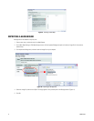
• Icons: An icon represents one or more devices in the Endura system. By inserting an icon onto the map and then associating devices with
that icon, Endura Mapping displays information about those devices through the icon. An icon changes color and becomes animated as
events occur on associated devices. Along with symbols, several aspects about icons can be edited: the size of an icon, the thickness of its
border, and its aspect ratio when a map is viewed at different zoom levels. When adding an icon to a map, you can choose from a
predefined set of symbols that can be associated with an icon or custom icons that can be created in another drawing tool and added to
Endura Mapping. For instructions on creating custom icons, refer to the Creating Custom Icons manual on the resource CD.
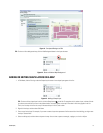
• Icon layers: By default each map has at least one icon layer. An icon layer is a transparent grouping of icons on a map that sits on top of
or below other icon layers. Use icon layers to organize icons on the map that represent devices at a site. Maps can contain several icon
layers to organize the devices for easier viewing. The relative position of icon layers can be reorganized. Include one or more icon layers in
a custom view to display only those icon layers.
• Shapes and shape layers: By default, each map has one shape layer. A shape layer is a transparent grouping of shapes on a map that
sits on top of or below other shape layers. Use shape layers to define areas of interest on your map. If you do not use a background image
for your map, shape layers create a visual representation of your site or building. Shape layers can represent such things as different areas
in a building or a special event. After they are created, shape layers can be displayed simultaneously or individually. Custom views can be
created to display a specific set of shape layers and icon layers.
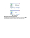
• Hyperlinks: A hyperlink is a connection to another map, file, or URL address. You can add hyperlinks to any object on a map to the
following types of files:
– Other maps in the Endura Mapping system: Hyperlinks to maps can be created for a map that is related hierarchically to the current
map or to any other map in the system. For example, alarm information on a child map can be viewed from the parent map on which
the hyperlink was created or on the child map. As events occur on the linked map, the shape on the parent map changes color. This
provides a visual cue while monitoring a map that events are occurring that can be viewed from the linked map. Clicking a hyperlink to
another map displays that map.
– Files stored in a network or in a local folder (for example, a set of instructions related to the map): When creating hyperlinks
to local folders, it is important to share the linked folder so that other computers on the network can access the folder. If not, files in
local folders might not be available to an operator who is trying to link to the file from a computer on the network. Refer to your
operating system instructions for information on sharing local files or folders across a network.
– URL addresses of resources stored on a local intranet or on the Internet: Clicking a link to a URL address opens a Web page in
the default Web browser. For example, you might link to an external Web site that displays directions to the location associated with
the map.
• Parent map: The parent map is the map to which the currently selected map is related hierarchically. This setting is optional.