


1
BlueChart g2 User’s Guide
gettIng started > overvIew
GettInG started
BlueChart g2 data is available in two formats:
• Preloaded on your Garmin chartplotter—coverage includes the costal United States
and contains all the detail of traditional BlueChart and some of the previously listed
additional functions (page ii).
• Preprogrammed Garmin data card—coverage is expanded beyond the costal United
States and regions are available throughout the rest of North and South America as
well as Europe (Atlantic) and Asia (Pacic). Garmin BlueChart g2 preprogrammed
data cards contain additional data including highly detailed coastal roads and points of
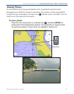
interest such as restaurants, lodging, local attractions and more. Full-color aerial photos
of ports, marinas, bridges, and navigational landmarks are also included on many
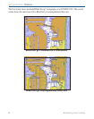
BlueChart g2 preprogrammed data cards (see page 2 for a visual comparison).
NOTE: Garmin BlueChart g2 preprogrammed data cards work only with
BlueChart g2 compatible Garmin units. Look for the BlueChart g2 compatible logo
on the product packaging.
Current owners of Garmin GPSMAP 276, GPSMAP 376, GPSMAP 3005C, GPSMAP 3006C,
and GPSMAP 3010C chartplotters can also use BlueChart g2 preprogrammed data cards after
loading a required software update.