


vi
BlueChart g2 User’s Guide
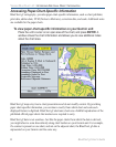
IntroductIon > overvIew
Additional BlueChart g2 enhancements include:
• Shaded depth contours
• Mariner’s eye view map perspective
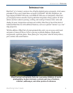
• Port plans and navigationally signicant photos (Preprogrammed data card only)
• Improved IALA symbology
• Intertidal zones with spot soundings
• Navaids with view range and coverage
• Data on tides and currents
• Coastal roads, marinas, points of interest (Preprogrammed data card only)
• Wrecks, restricted areas, anchorages
• Shoals, spoilage, and more
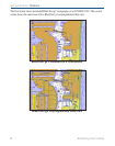
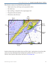
Like all BlueChart cartography, BlueChart g2 cartography is styled to match the appearance
of paper charts when displayed on your Garmin chartplotter. Sharp, colorful, nely detailed
graphics let you see every cartographic contour and feature, with a minimum of panning and
zooming to bring the chart data into focus.