


Portions of BlueChart data may be subject to the following copyrights and notices:
© 2005 MapTech, Inc.
The chart information in this product is reproduced, in whole or part, with the permission of the following national hydrographic ofces and
other organizations: Australian Hydrographic Service; Editrice Incontri Nautici (Bolina); Hydrographic Institute of the Republic of Croatia;
Kort & Matrikelstyrelsen, Denmark, license no. G.9-2002; Estonian Maritime Administration (EMA) © 2006; Finland Hydrographic Ofce,
license no. FMA 877/721/2004; Service Hydrographique et Océanographique de la Marine (SHOM, www.shom.com), France, Contract nº
E 67/2005; Bundesamt für Seeschifffahrt und Hydrographie (BSH), Germany, license no. 8095-01/2004-02 ÖA03; © Her Majesty in Right
of Canada, Department of Fisheries and Oceans (2006), 20060101-G;.Great Barrier Reef Marine Park Authority (GBRMPA); Hellenic Navy
Hydrographic Service (Greece), license no. 171.7/22/03; Hydrographica chart data contained in this product is © 2005-2006 Hydrographica;
©Copyright Icelandic Coast Guard Hydrographic Department, (2004-2006). All rights reserved, license no. IS AC-001-Garmin; Imray
Laurie Norie & Wilson Ltd. UK; Istituto Idrograco della Marina, Italy; Maritime Administration of Latvia (LHS) © 2006; Maritime Safety
Queensland and is © State of Queensland. All rights reserved; Netherlands Hydrographic Ofce 2005-2006, license no. NL AC-002-Garmin;
Land Information New Zealand (Crown copyright reserved); Norwegian Hydrographic Service, license no. NO24/021001/1; ©Copyright
National Hydrographic Ofce, Sultanate of Oman (2005-2006), OM AC-001-Garmin. All rights reserved; ©Copyright Instituto Hidrográco
of Portugal, (2003-2006), PT AC-002-Garmin. All rights reserved; Lewis Offshore Ltd. (© 2003-2006); Russian Hydrographic Ofce; South
Africa Hydrographic Ofce; ©Copyright Instituto Hidrográco de la Marina, Spain, (2003-2006), ES AC-001-Garmin; Swedish Maritime
Administration, license no. 03-01453; and ©British Crown Copyright, (2001-2006), GB AC-002-Garmin. All rights reserved. Wavey Line
charts are produced, in part, from products and with the agreement of Wavey Line Ltd.
This product has been derived in part from material obtained from the UK Hydrographic Ofce with the permission of the UK Hydrographic
Ofce, Her Majesty’s Stationery Ofce and the following authorities: Hydrographic Department of the Icelandic Coast Guard, Netherlands
Hydrographic Ofce, National Hydrographic Ofce, Sultanate of Oman , Instituo Hidrográco of Portugal, Instituto Hidrográco de la Marina,
Spain.
This product has been derived in part from material obtained from the UK Hydrographic Ofce with the permission of the UK Hydrographic
Ofce, Her Majesty’s Stationery Ofce and the following port authorities for United Kingdom: Aberdeen Harbour Board, Associated
British Ports (includes Ayr & Troon, Barrow, Cardiff & Barry, Fleetwood, Garston, Ipswich, King’s Lynn, Lowestoft, Newport, Plymouth,
Silloth, Southampton, Swansea & Port Talbot, and Teignmouth), Cattewater Harbour Commissioners (Cattewater, Plymouth), Chichester
Harbour Conservancy, Clydeport Operations Limited, Cromarty Firth Port Authority, Cowes Harbour Commission, Dart Harbour and
Navigation Authority, Dover Harbour Board, Falmouth Harbour Commissioners, First Corporate Shipping Limited (Bristol), Fowey Harbour
Commissioners, Fraserburgh Harbour Commissioners, Gloucester Harbour Trustees, Harwich Haven Authority, Heysham Port Limited, Imerys
Minerals Ltd (Par), Inverness Harbour Trust (Inverness, Inverness Firth), King’s Lynn Conservancy Board, Langstone Harbour, Larne Harbour
Limited (Larne, Cairnryan), Littlehampton Harbour Board, Londonderry Port and Harbour Commissioners, Manchester Ship Canal Company,
Medway Docks and Harbour Company Limited, Mersey Docks & Harbour Company (Mersey, Liverpool, Birkenhead), Milford Haven Port
Authority, Montrose Port Authority, Newhaven Port and Properties Limited, Orkney Islands Council, Padstow Harbour Commissioners, PD
Teesport (excluding Bathymetry data), Poole Harbour Commissioners, Port of Boston Limited, Port of London Authority, Port of Sunderland,
Port of Tyne Authority (Tyne), Port of Wisbech Authority, Port of Workington, Portland Harbour Authority Limited, Ports of Truro & Penryn,
Portsmouth Commercial Port, Seaham Harbour Dock Company, Scrabster Harbour Trust (Scrabster), Shetland Islands Council, Shoreham Port
Authority, Stena Line Ports Limited (Fishguard, Fleetwood, Holyhead, Stranraer), Teignmouth Harbour Commission, Thanet District Council
(Ramsgate), Torbay Council Marine Services (Tor Bay; Torquay, Brixham, Paignton), Warrenpoint Harbour Authority, Weymouth & Portland
Borough Council, and Whitstable Harbour. For Channel Islands: Jersey Harbours and States of Guernsey Harbour Authority. For Isle of Man:
Isle of Man Harbours Division. For Republic of Ireland: Bantry Bay Harbour Commissioners, Drogheda Port Company, Dublin Port Company,
Dun Laoghaire Harbour Company, and Port of Cork Company. © the British Crown, 2001-2006. All rights reserved.
Some data and information contained in these Products are © Commonwealth of Australia, Australia Hydrographic Service, Maritime Safety
Queensland and is © State of Queensland, Certain zoning information in this product is © Great Barrier Reef Marine Park Authority; and is
used under license with the permission of the Great Barrier Reef Marine Park Authority. All rights reserved. Apart from the uses permitted to
the licensee under the license, the information may not be modied or exploited by reverse engineering of formats and encryption or copied,
reproduced, translated, or reduced to any electronic medium or machine readable form, in whole or part, without the prior written consent of
the Great Barrier Reef Marine Park Authority, the Maritime Safety Queensland and © 2002-2006 Her Majesty the Queen in Right of Canada,
Canadian Hydrographic Service / Sa Majesté du chef en Canada, Service Hydrographique du Canada and/or Nautical Data International,
Inc. Garmin International, Inc. is an authorized user and licensee of selected Australia Hydrographic Service data products under licensing
agreement 0548FL and Nautical Data International Inc. data products under Licensing Agreement number 240502001-001/2 and 021704-087.
Apart from the uses permitted to the licensee under the licensing Agreements, the information may not be modied or exploited by reverse
engineering of formats or encryption or copied, reproduced, translated or reduced to any electronic medium or machine readable form, in whole
or part.
Reeds Almanacs port services data contained in this product is © 2004-2006 Adlard Coles Nautical. Certain port services data contained
in this product is © 2005-2006 Batmagasinet, Certain port services data contained in this product is © 2006 Boatlaunch Ltd., © 2005-2006
BLOC MARINE Almanac & Cruising Guide, © 2004-2006 Bolina - Editrice Incontri Nautici, © 2005-2006 Gasthamnsguiden SXK AB, and
© 2005-2006 Kort & Matrikelstyrelsen. The Explorer Charts logo is a registered trademark of Lewis Offshore Ltd., publishers of the Explorer
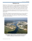
Chartbook series. Photos courtesy of © 2006 CMT Group 1, Inc. and Garmin International, Inc.
** BlueChart g2 does not contain photos for all cards. Garmin is continuing to expand our growing database of navigationally signicant photos
** Navteq road data is included for many BlueChart g2 data cards. Not all data cards contain road data.
** WhereisTM Map data is included in Australia BlueChart g2 data cards. Whereis © 2006 Telstra Corporate Limited and its licensors.