


Honeywell
MK VI MK VIII EGPWS Installation Design Guide
Proprietary notice on title page applies
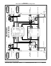
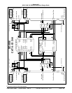
CAGE CODE: 97896 SCALE: NONE SIZE: A DWG NO: 060-4314-150 REV:
SHEET
89
alerts if the boundaries of these envelopes conflict with obstacle elevation data in the obstacle database (similar
to the Terrain Awareness function). Obstacle data is currently available for North America and parts of the
Caribbean and Europe. Not all obstacles will be contained in the database.
Category 7 enables Obstacle Awareness if TA&D is not disabled in Category 6.
Note: TAD & TCF must be enabled if Obstacle Awareness is enabled.
3.9.5 Bank Angle Callout Enabling
The Bank Angle feature provides protection for over banking during maneuvering on approach or climb-out and
while at altitude. In addition, it protects against wing or engine strikes close to the runway. For airplanes fitted
with an autopilot, additional protection is provided if the autopilot is engaged by advancing the roll angle limit to
33 degrees. The additional ‘autopilot engaged’ protection applies to all software versions for GA FAST and GA
SLOW aircraft types, whereas it is available in software version –008 or later for Bizjet aircraft types. The Bank
Angle callout can be enabled or disabled as appropriate for this installation.
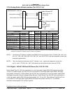
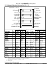
3.9.6 Flap Revers al
The Landing Flap discrete input is defined in Category 13. The Category 7 control is used to reverse the
defined logic to match aircraft wiring, if necessary.
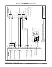
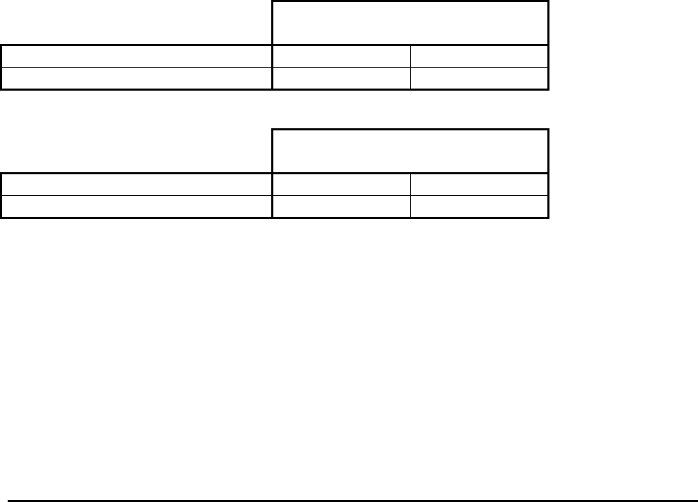
+28 VDC Landing Flap discrete (J1-37) active position:
Flap Reversal
Flap Discrete (Category 13)
False True
Landing Flap discrete = +28V Flaps Up Flaps Down
Landing Flap Discrete = Open (or GND) Flaps Down Flaps Up
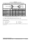
Ground seeking Landing Flap discrete (J1-18) active position:
Flap Reversal
Flap Discrete (Category 13)
False True
Landing Flap discrete = GND Flaps Up Flaps Down
Landing Flap Discrete = Open (or +28V) Flaps Down Flaps Up
3.9.7 GPS Altitud e Reference
The GPS Altitude (ARINC 429 label 076, Category 3) may be referenced to mean sea level (MSL) or WGS-84.
Determine which reference the GPS position uses and set the GPS Altitude Reference accordingly in this
Category.