


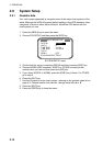

2. OPERATION
2-18
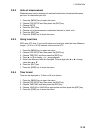
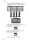
2) Use the Omnipad to choose WAAS satellite search method, AUTO or
MANUAL as appropriate. For MANUAL, press the [ENT] key, enter
appropriate WAAS satellite referring to the illustration below and then press
the [ENT] key.
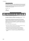
Provider GEO Satellite Longitude
POR (134) 178°E
WAAS
AOR-W (122) 54°W
AOR-E (120) 15.5°W
EGNOS
IOR (131) 64.5°E
122
AOR-W
54°W
120
AOR-E
15.5°W
131
IOR
64.5°W
134
POR
178°E
118°W 34.75°W 24.5°E 121.25°E
2°
2°
2° 2°
Longitude Range Satellite
120.25
°
E to 117
°
W 134
119
°
W to 33.75
°
W 122
35.75
°
W to 25.5
°
E 120
23.5
°
E to 122.25
°
E 131
One-degree threshold
GEO satellite and coverage area
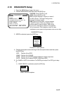
3) CORRECTIONS DATA SET is selected; press the [ENT] key.
CORRECTIONS DATA SET determines how to use the WAAS signal. Use
the default setting “00”. Do step 6 and 7 for DGPS.
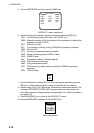
6. Choose DPGS STATION and press the [ENT] key.
AUTO
MANUAL
AUTO/MANUAL options
7. Choose MANUAL or AUTO as appropriate and press the [ENT] key. For
AUTO got to step 8. For MANUAL do the following:
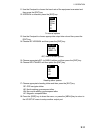
1) RATE is selected; press the [ENT] key.
50BPS
100BPS
200BPS
Baud rate options
2) Choose appropriate baud rate and press the [ENT] key.